Miners, Exploration Companies, Exploration Drillers, Farmers, Agribusinesses And Aboriginal Stakeholders Should Look to Geomoby Location Technology – Its Protéger l'application est un outil essentiel pour gérer les risques alors que les nouvelles lois sur le patrimoine aborigène en Australie-Occidentale entrent en vigueur le 1er juillet
‘We are here to help manage risk and our real-time data assists with ESG’
Australian technology company GeoMoby – shaping the future of location intelligence – says its heritage monitoring technology can reduce the risk of mining companies and agribusinesses trespassing onto Aboriginal heritage sites, an activity that could attract huge fines from July 1, 2023, when the new WA Indigenous heritage laws come into effect.
“We urge mining and exploration companies and others such as exploration drillers, farmers, agribusinesses and Aboriginal stakeholders to look at our technology. Our Protéger technology defines restricted areas and is a vital tool to manage risk and protect heritage sites. We are here to help, and our data collection facility assists with ESG and governance requirements,” says GeoMoby director Mathieu Paul.
GeoMoby is currently working with several mining and renewable energy companies to use its location intelligence technology – Protéger – to protect cultural heritage sites. GeoMoby says its technology can be incorporated into Aboriginal Cultural Heritage Plans to benefit all parties.
https://www.wa.gov.au/system/files/2023-06/20230427-ach-management-plan.pdf
“Our technology is a great tool to manage risk and can be implemented very easily to help mining and agribusiness operations run smoothly,” says Mathieu Paul, GeoMoby Director.
“We recognise that many – working in the mining and farming sectors – are anxious about the new WA heritage laws. From July 1, in Western Australia, there are potentially much larger fines if people and vehicles trespass on heritage sites.”
La technologie de localisation numérise la cartographie des zones culturellement sensibles et fournit une plate-forme basée sur une application pour alerter les utilisateurs des terres travaillant dans ces zones. Cette technologie réduit immédiatement les risques et simplifie un processus qui repose actuellement fortement sur l'intervention humaine.
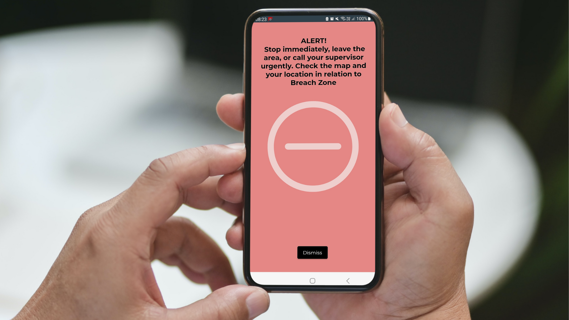
“Our technology can monitor people and vehicles in real time, and record that data so all parties – including, for example, miners and Aboriginal groups – will know if there is any illegal or unauthorised activity. For example, if a truck drives over a culturally-sensitive area – such as a songline or special part of a river – an alarm will be triggered, in real time. Unauthorised activities are recorded. Protéger les clients peuvent également mettre en place des zones tampons autour des sites patrimoniaux qui déclenchent des alertes d'avertissement. Cette technologie est extrêmement utile si les entreprises et les organisations gèrent de grandes équipes dans des régions éloignées.
“Conversely, if mining companies and agribusinesses have acted with cultural sensitivity and respect to Aboriginal heritage sites, then they can prove, with Protéger données, qu'ils ont adhéré aux accords patrimoniaux. Les données concrètes seront de plus en plus importantes, car la mesure des résultats ESG est désormais un élément crucial de la licence sociale des entreprises opérant dans la communauté d'Australie-Occidentale et de leurs exigences de gouvernance continues.
Exemple
“GeoMoby powered data – collected through its Protéger app – can be used as part of reporting and measuring ESG (Environmental Social Governance) outcomes. You can imagine, mining and agribusiness companies employing large numbers of people, and training would detail which heritage sites require protection. However, it could be easy for company employees, say in exploration teams, to make mistakes in vast, remote areas of Western Australia. Our technology can limit risk for companies, and trigger alarms when transgressions are made, so mistakes can be quickly rectified. We think every exploration and mining company, and a vast number of farmers, should review our technology, especially in light of these new laws.”
The new Aboriginal Cultural Heritage Act 2021 was passed in Western Australia’s parliament, after Juukan Gorge was destroyed in the Pilbara in 2020. Penalties for damaging a cultural heritage site now range from $25,000 to $1m for individuals and $250,000 to $10m for corporations, as well as up to five years in jail.
Il y a environ 130 sociétés minières opérant dans l'État et 5200 agriculteurs en Australie occidentale.
Comment ça marche?
“GeoMoby’s technology uses location services including GPS, fusion sensors and our own patented live tracking algorithms in order to geofence sites and trigger an alert if users enter or come within close proximity of a heritage site, even in remote areas with no connectivity,” says GeoMoby founder Chris Baudia. “Receivers can be carried on-person, in vehicles, machinery or equipment, with the app compatible to most modern devices including phones and tablets. It can also operate with smart phones. The technology allows those operating on site to create or upload geofences on a map from any GIS systems, then define different alerts and triggers, while ensuring minimum drain on the device battery. Information is then uploaded to a cloud-based platform with replay features and reporting capabilities for compliance purposes.”
“We know our technology is best in class, as recent trials with large energy companies – monitoring heritage sites –have proven that, we are delighted to assist Australian companies establish best practice in terms of heritage management,” Baudia said.
S'il vous plaît voir une vidéo explicative sur GeoMoby’s Protect solution: https://youtu.be/zd3Tj0L-2gs
Here is a link to a film showing GeoMoby’s flagship technology used in underground mines: https://geomoby.com/case-study/underground-asset-management/
Pour plus d'information veuillez contacter:
Cate Rocchi, Perth Media cate@perthmedia.com.au 0428431699
À propos de GéoMoby
GeoMoby, basé à Perth, fournit une plate-forme de visibilité tout-en-un permettant une surveillance en temps réel des actifs et des personnes. L'objectif de GeoMoby est de changer la façon dont les entreprises prennent des décisions et atteignent les gens, pour les aider à contrôler leurs données et leur avenir.
It was established in 2013, in Perth, by founder and CEO Chris Baudia. GeoMoby’s leadership team is also consists of Mathieu Paul who was appointed as a director and head of strategy in 2016. Mathieu oversees sales and marketing. In September 2021, Andrew Rouse – an experienced mining professional with a passion for enhancing the METS (mining equipment technology services) sector, also joined GeoMoby as a director. Andrew helps develop strategic technology, software, and B2B partnerships in conjunction with Chris and Mathieu. GeoMoby employs 14 staff. Most are software specialists and based in Perth but some are located remotely. GeoMoby values highly its hard-working team, a priceless asset for any business. Its years of investment in R&D before going to market have ensured a quality, tested and proven, cost-effective, outcome-based offering that can now be delivered to market. In late 2022, GeoMoby undertook a successful capital raising of $3m, the second funding round undertaken by GeoMoby. In 2021, the company raised $1.25m.
L'effondrement d'une mine souterraine inspire la technologie
Chris Baudia was inspired to create GeoMoby underground technology – on a visit to Australia from France more than a decade ago – after hearing about an underground mine collapse. Lives were lost and rescue efforts were negatively impacted by not knowing, in any accurate way, where those trapped were located. He knew that he could develop a technology to avoid, or greatly improve, positive outcomes in such incidents in the future, and so, the idea of GeoMoby was born.
It is imperative that every team member returns safely to their family at the end of their shift, but what you can’t measure, you can’t manage, says founder Chris Baudia. This is particularly important in challenging environments such as mining (where staff, vehicles and machines are located underground) and visibility is limited. Compound these challenges, with a work environment increasingly impacted by health issues, and it is clear businesses must work smarter to ensure the safety of their teams. With our technology, staff health metrics can be monitored in real- time from the moment they arrive on site, detecting emergency situations the moment they arise, and prompting immediate action. Location-based safety analytics are crucial to implementing a safe system while ensuring little impact on production.
Technologie
Underground mines: GeoMoby technology is based on Bluetooth and a proprietary mesh network. Nodes are bright green and the size of a lunchbox. Many are fixed throughout mines. GeoMoby has a patent for its underground location technology. For underground installation, onsite electricians are not required. Mining operations do not need to be shutdown – the technology is fully wireless and cable free.
There are two ways of putting nodes on rock walls: nodes can be strapped onto existing underground mesh which is commonly onsite or they can be bolted onto walls. Underground installation generally takes less than an hour of training. GeoMoby technicians easily attach nodes or ‘green lunchboxes’ underground at strategic intervals, by hooking them to mesh, often already on walls.
C'est très simple et GeoMoby a l'expérience d'installer des kilomètres de couverture en quelques heures seulement. Une petite équipe se rendra sur place et supervisera l'installation initiale. L'espace maximum entre les nœuds est d'environ 400 m sous terre et 600 m dans les fosses à ciel ouvert. L'ensemble du processus de déploiement dure généralement environ deux jours.
“Many underground mines – in Western Australia and the world – still use employee monitoring systems that revolve around whiteboards, spreadsheets and tag boards,” said Chris Baudia, Director of GeoMoby.
« Des erreurs concernant les équipements et les personnes peuvent facilement être commises, notamment lors du changement d'équipe ou lors d'une urgence. Il n’y a aucune excuse en 2023 : notre technologie peut surveiller les travailleurs à tout moment, garantissant que chacun rentre chez lui en toute sécurité, chaque jour. Il s’agit d’un outil précieux et moderne dans la trousse de tout directeur de mine garantissant la santé et la sécurité des grandes équipes travaillant sous terre. Les entreprises doivent toujours savoir où se trouvent leurs employés, sinon, en cas d’urgence, les délais de réponse peuvent être longs. Trop souvent, dans les mines souterraines, il peut être impossible de localiser rapidement et avec précision le personnel impliqué dans des incidents critiques afin que l'intervention d'urgence appropriée puisse être mise en œuvre en temps opportun.
Surface mines: GeoMoby technology is a ‘fusion’ of various technologies including small batteries, smart phones, GPS, BLE tags and geofences. GeoMoby has a geofencing patent for this.
La technologie GeoMoby en bref :
La technologie GeoMoby peut résoudre une série d'inefficacités opérationnelles sur les sites miniers qui peuvent survenir en raison : du manque de données précises et opportunes ; les questions d'engagement des parties prenantes ; et les limites de conformité ESG, spécifiquement liées à la protection du patrimoine culturel.
GeoMoby possède des capacités sans précédent pour transformer les données en valeur en temps réel – offrant une géolocalisation intérieure et extérieure avec une précision supérieure aux normes de l'industrie – ainsi qu'une consommation de batterie négligeable, une solution qu'elle a brevetée.
GeoMoby utilise l'intelligence de localisation, la géolocalisation, les données contextuelles, le géorepérage, l'analyse de localisation et un réseau indépendant de l'opérateur. Cela résout de nombreux problèmes en fournissant une plate-forme de suivi en direct (LTP) hyper précise et un système de localisation en temps réel (RTLS) pour les opérations souterraines et de surface.
La technologie riche en fonctionnalités de GeoMoby permet également aux utilisateurs de déclencher des alertes et des actions basées sur des ensembles prédéfinis de conditions, notamment le temps de séjour, la température corporelle, la météo, le trafic en temps réel, le profil de l'utilisateur, etc. Des barrières géographiques complexes (limites géographiques virtuelles) peuvent être configurées pour déclencher des actions personnalisées lorsqu'elles sont franchies.
La technologie offre une plate-forme SAAS basée sur le cloud. GeoMoby agit comme un pont qui génère des données puissantes et les convertit en informations significatives à partir desquelles des décisions commerciales critiques peuvent être prises pour atteindre les objectifs de santé, de sécurité, d'efficacité et de productivité.
Western Australian Government’s Work Health and Safety Act:
“Western Australia introduced new tougher laws on work, health and safety (WHS) in March, 2022 and now, in 2023, there are no excuses,” said Chris Baudia of GeoMoby. It is particularly important for WA underground mines to
embrace world-leading technology. The State Government’s Work Health and Safety Act 2020 (WHS Act) replaces previous legislation circa 1984, effectively aligning all workplaces under a single act to improve protections for WA workers. This is the most significant upgrade to WHS legislation in 30 years. The new WHS Act introduces the offence of ‘industrial manslaughter’ – the offence carries a maximum penalty of 20 years imprisonment and a $5m fine for an individual, and a maximum fine of $10m for a corporation or employer. Senior decision-makers must exercise due diligence to ensure compliance, with responsibility firmly sitting with management when it comes to workplace safety.
À propos de Chris Baudia, directeur
Chris is an entrepreneur, inventor and driving force behind GeoMoby. In the past, he managed multi-million dollar projects for global consulting companies. He holds a Master’s Degree in Computer Science and Telecommunications and is a certified Scrum Master since 2009. He has been a QuantumTX National Finalist (WA winner 2022), Hot 30 Core Innovation award winner (2022), a finalist in the RISE Business Award for Startup of the Year (2020), a recipient of the Amcom Upstart Investment Program in 2015 and WA Innovator of Year finalist in 2013. He lives in Perth, Western Australia and is originally from France.
À propos de Mathieu Paul, directeur
Mathieu est administrateur de GeoMoby depuis six ans et a joué un rôle déterminant dans la récente levée de fonds de $3m.
Il se concentre maintenant sur le développement des affaires et les ventes chez GeoMoby.
Mathieu has a Master’s Degree in Entrepreneurship, Finance, Project Management and Business Strategy from NEOMA Business School in France and received a Bachelor of Business Administration at Chulalongkorn University in Thailand.
Avant GeoMoby, Mathieu a travaillé en audit/analyse financière chez KPMG et Grant Thornton. Il a également été employé par Siemens France Chine et l'Ambassade d'Afrique du Sud à Paris. Il a de l'expérience dans le conseil en gestion, les évaluations d'entreprises et les ventes et acquisitions. Mathieu vit à Perth, en Australie-Occidentale et est également directeur chez Insight Advisory Group.